ESRI IMGIS 2024: Showcasing adjust.IT for ArcGIS
Our teams from the USA and Australia will be attending the ESRI Infrastructure Management & GIS (IMGIS) Conference 2024 in Palm Springs showcasing our product, ArcGIS Marketplace product adjust.IT for ArcGIS as well as our data services offerings and more. This event is one of the premier gatherings in the GIS and infrastructure management space, and we’re thrilled to be part of it.

Why is the ESRI IMGIS Conference a Must-Attend?
The ESRI IMGIS Conference brings together experts from sectors like utilities, transportation, telecommunications, and public services to explore the future of GIS technologies.
For us, the IMGIS Conference provides the perfect platform to showcase the Esri ArcGIS Marketplace Product adjust.IT for ArcGIS.
Our solution simplifies and enhances spatial data adjustments within ArcGIS Pro and ArcGIS Online. We’re excited to connect with industry leaders, exchange ideas, and demonstrate how adjust.IT can significantly improve network data accuracy.
What is adjust.IT for ArcGIS?
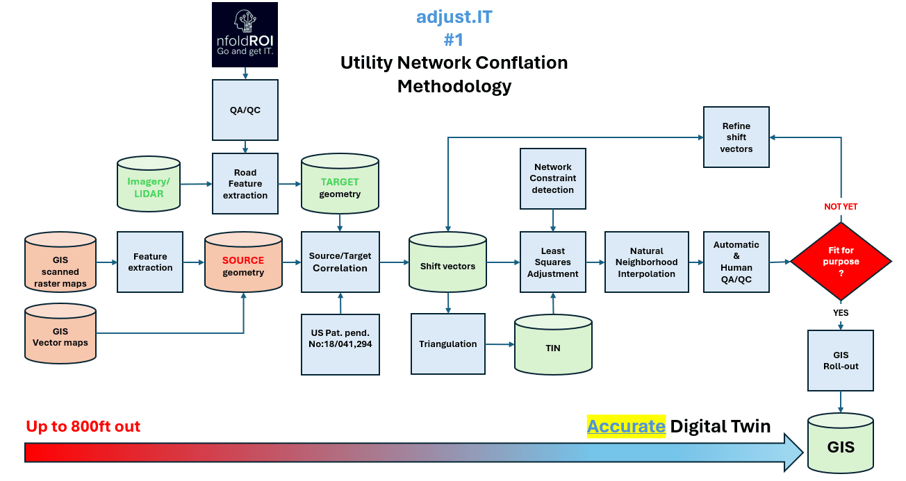
adjust.IT for ArcGIS is an advanced system and Methodology created to address a critical challenge in GIS projects: ensuring spatial data accuracy. Whether it’s reconciling inconsistencies from field data collection, aligning datasets from different sources, or adjusting for changes in the physical landscape, adjust.IT streamlines the entire process. The solution works directly within ArcGIS, enabling users to automate many traditionally manual tasks involved in spatial data adjustments. With an intuitive interface and customizable parameters, it offers a seamless way to improve data precision, reduce errors, and speed up workflows.
Since its first commercial release in 2000, adjust.IT has evolved into the #1 global conflation solution, with more than 400 million coordinates successfully adjusted to date for some of the largest Utility and Telco GIS in the World.

Cut down on time-consuming manual work with automation that still maintains high accuracy.
Seamless ArcGIS Integration:
Designed to integrate natively within ArcGIS, making it an easy addition to existing GIS infrastructures.
Customizable Controls:
Users can fine-tune adjustment parameters to fit their project’s unique needs, ensuring flexibility and precision.
Detailed Reporting:
Get comprehensive reports on the adjustments made, which will help teams maintain transparency and trust in their data.
What We’re Looking Forward To
Beyond showcasing adjust.IT, we’re excited to attend the various sessions, keynotes, and workshops that IMGIS 2024 has in store.
We also look forward to networking with other industry professionals and hearing firsthand how organizations use GIS to solve real-world infrastructure challenges.
The insights we gain from these conversations will help us continue refining and expanding adjust.IT’s capabilities.
Why You Should See Us at IMGIS 2024
If you’re attending the IMGIS Conference, chat to one of our friendly and knowledgeable people.
You’ll see firsthand how our solution can help your team manage spatial data adjustments more efficiently, with fewer errors and more control over the process.
We’ll be available throughout the event to answer questions and discuss potential applications for your organization.
We hope to see you at the conference! Stay tuned for updates and insights from the event, and if you’d like to schedule a one-on-one session with our team while we’re there, feel free to get in touch.
